Ireland Offline Maps and Offline Navigation
- No expensive 3G/4G data connection, wifi or internet connection required for voice turn-by-turn navigation. Save on your data usage. Turn your iPhone or iPad into a mobile GPS navigation device.
- No map download required. All maps contained in the initial download of the app.
- No subscriptions, in-app purchases or ongoing costs. Free to use after your initial purchase.
A simple to use, detailed navigation app with spoken instructions designed specifically for the iPhone and iPad. With this app you no longer have to worry about finding your way to any destination in Ireland. No need for paper maps. No matter where you are or where the journey takes you, the app can be used anywhere in Ireland.
Travelling to Ireland? Great for visitors who need a GPS navigation device during their stay without having to spend lots of money on one. Save your data allocation and money as you enjoy street by street navigation without the need for any mobile data connection.
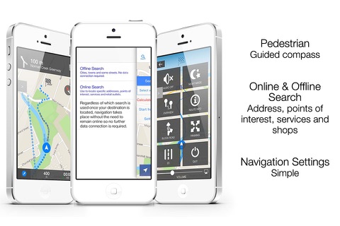
The app has both off-line and on-line searching. On-line searching requires an internet connection for the actual search and uses very little data. Once the destination has been selected all navigation is off-line and data free.
NOTE - For navigation the app does require that your iPad has a SIM slot (3G/4G slot), as only these iPads have the full GPS capabilities and antennas. You do not need a SIM to be installed for the data free GPS navigation. A WiFi-only iPad does not contain the in-built GPS that a WiFi+Cellular (SIM slot) iPad does and we do not recommend this app for Wifi only iPads. If your iPad is Wifi only, then you will be able to view the entire Ireland maps, however full navigation will not function. The app is suitable for all iPhones.
• All Ireland map data stored on your iPhone or iPad - no download costs for mapping or navigation
• Full-fledged turn-by-turn voice navigation including street names
• Local online search for a specific address or place, service and shop. Pizza Library or Hostptal
• Set your own speed warnings for in and out of town
• Street sign displays
• 3D-view, with user options for 2D view during navigation
• Selectable Route Types - Car efficient, fastest, shortest, Pedestrian (options map turns to north facing or direction), Bike fastest, shortest and quietest
• Options to avoid toll roads, ferries and highways
• Route simulation mode to preview your trip
• Automatic night and day mode
• Up to three alternative routes to choose from
• Optional setting of a waypoint for a place you want to visit along your route
• Time remaining in journey, your actual speed and distance remaining
• Supports landscape and portrait views
Remember for safety sake - do not adjust the settings on this app while driving. The iPad version is perfect for the passenger ‘navigator’. Position your device safely, out of the way of airbags and not obstructing the drivers vision. You are responsible for ensuring the road is safe to travel on. We do not accept responsibility for errors generated by unreported road works or the weather. You assume total responsibility and risk for using this satellite navigation app. Please note that as with all navigation apps, continued use of GPS running in the background can decrease battery faster than normal.
Tutorial videos at www.outbacktouring.com.au
Please email [email protected] for support or to bug report. Thanks. :-)


